


High-tech mapping, robots and drones aid Cyclone Debbie crop response


An Australian crop mapping project is already proving its worth in the aftermath of Cyclone Debbie, allowing industry and government to better assess damages and help with response and recovery. 


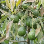
Produced using a range of satellite and aerial imagery, and informed by on-ground data collected by industry using a purpose-built app, the map shows macadamia, avocado and mango orchards impacted in the area the cyclone hit land.
The wider mapping project is due for completion in 2018, and is supported by Horticulture Innovation Australia with funding from the Federal Department of Agriculture and Water Resources' 'Rural R&D for Profit programme', coordinated by the University of New England.
"The hours of mapping that’s been generated through this ambitious four-year project is already showing its worth – and this is just the tip of the iceberg," Horticulture Innovation Australia chief executive John Lloyd said in a release.
"The mapping is not only priceless in instances such as Cyclone Debbie, it’s critical for biosecurity response and planning activities."
Lloyd said scientists were continuing to log data being captured through a combination of robots working autonomously up and down rows in key growing regions, the use of drones, near infrared spectroscopy guns and satellite imagery.
"Most importantly, citizen science is also driving this national mapping initiative. We are encouraging growers to ‘Get the app and improve the map’ to help strengthen the data for the benefit of Australia’s mango, macadamia and avocado industries with the potential to expand the research to include other horticultural sectors in the future," he said.
Rachel McKenzie from Queensland’s peak horticulture representative body, Growcom, said the cyclone impact map had proven invaluable and she looked forward to more resources to come.
"Gaining access to the tree cropping map layer has enabled Growcom to accurately measure the extent of damage done post Cyclone Debbie and has played a key role in quickly validating and quantifying what would normally take weeks," she said.
"The map layer will be a valuable tool in future extreme weather events and will help Growcom make a faster response for better support of our industry," she said.
Australian Mangoes chief executive Robert Gray said this new mapping capability provided a direct benefit to growers.
"From an industry viewpoint, having the resources developed through the remote sensing project to quickly and accurately identify all of the orchards in the Bowen/ Proserpine region has meant we are in a much better position to respond appropriately," he said.
The web map will work in any browser on any smart device and shows Cyclone Debbie's track, points and predicted path, sourced from the Bureau of Meteorology.
It shows three buffers (50km, 100km and 200km) to infer impact zones and the buffering ceases inland from the coast where Debbie was downgraded to a low-pressure system.
The web map has the capability of switching between different base maps (e.g. imagery, terrain or streets) and has a search function to find an address or place of interest.
See the Cyclone Debbie tree crop impact map, imagery courtesy of the Queensland Department of Natural Resources and Mines. See the Land Use Survey app for IOS and Android.


Subscribe to our newsletter